Long Marine Stranding Map
Alexa Modular Adapter
Alexa Enabled Universal Remote
ARbot
AutoIrrigation
Automated Hydroponics
Autonomous UV-C Sanitation Bot
Bus Tracker Project
Bus Tracking System
Bus Usage Monitor
Classmates Search
Cloud Native Wireguard
CO2 Monitoring System
Diabetics Companion
Edu Plastic Pollution
EDU (CPU)
Googun
H2Eyes
IMDB on FPGA
Indoor Robot
Induction Motor
Land Trust Management
Learning Storage Networks
Low Latency Gaming
Marine Plastics Monitor
ODS Web App Performance Tuning
Offroad Spotting Drone
ONI Code Visualization
Painless Healthcare Management
Parquet+OCI project
Preventing Vehicular Heatstroke
Remote Nuclear Monitoring
Rent-a-Driveway 2020
ResearchConnect
RREESS Microgrid Management
Save our Species 2020
SAWbots - Miniature Medical Robots
Self Stabilizing Personal Assistance Robot
Slug Charge
Slug Sat
Smart Cane
Smart Magazine Floorplate
Smart Park
Smart Seat Cover for Posture Detection
Smart Slug Bin
Soaring Slugs
Team Litter Buster
Understanding Healthcare Data
Vibrace
VoIP Management Assistant
Wildfire Detection Drone
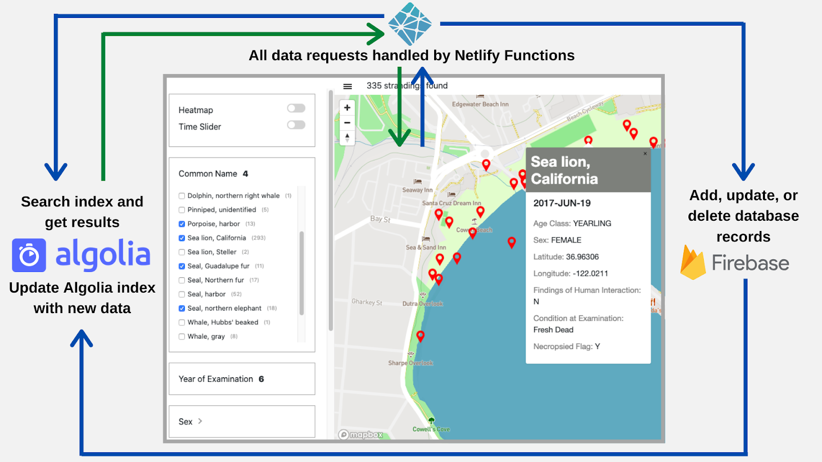
Abstract
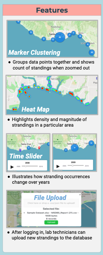
The stranding map is a web application to visualize marine mammal strandings of Santa Cruz county. This tool’s features include multi-attribute filtering, marker clustering, heatmap layer, time series animation, and data upload. This allows both the Long Marine Lab and the public to look at stranding data in a more intuitive and effective way.
Approach
- Firebase stores the stranding data. This can be updated easily when new strandings are reported.
- Mapbox displays all the marine mammal strandings on the map with their GPS coordinates and creates the heatmap view.
- Algolia allows us to achieve fast multi-attribute querying for the filter.
- Netlify hosts the web app and some of the backend code.
Overview
To drive many of its research projects, the UCSC Long Marine Lab (LML) collects data from examining strandings: an event in which a marine mammal has washed ashore, living or deceased. With this tool, lab technicians can view the data they’ve collected over the years on an interactive map. As a scientific tool, the stranding map opens up new avenues of data analysis for the lab and provides geospatial visualization for LML’s research in marine life, coastal conservation, and climate change. Making the map public can improve collaborative planning efforts and promote public involvement.
Check it out at lmlstrandingmap.netlify.app
Features
Acknowledgements
Thank you to our sponsors at the Long Marine Lab: Dr. Robin Dunkin and Amber Diluzio. We would also like to thank Professor Jullig and our TA’s Akila De Silva and Scott Davis that have provided support and mentorship throughout this project.