Offroad Spotting Drone
Alexa Modular Adapter
Alexa Enabled Universal Remote
ARbot
AutoIrrigation
Automated Hydroponics
Autonomous UV-C Sanitation Bot
Bus Tracker Project
Bus Tracking System
Bus Usage Monitor
Classmates Search
Cloud Native Wireguard
CO2 Monitoring System
Diabetics Companion
Edu Plastic Pollution
EDU (CPU)
Googun
H2Eyes
IMDB on FPGA
Indoor Robot
Induction Motor
Land Trust Management
Learning Storage Networks
Low Latency Gaming
Marine Plastics Monitor
ODS Web App Performance Tuning
Offroad Spotting Drone
ONI Code Visualization
Painless Healthcare Management
Parquet+OCI project
Preventing Vehicular Heatstroke
Remote Nuclear Monitoring
Rent-a-Driveway 2020
ResearchConnect
RREESS Microgrid Management
Save our Species 2020
SAWbots - Miniature Medical Robots
Self Stabilizing Personal Assistance Robot
Slug Charge
Slug Sat
Smart Cane
Smart Magazine Floorplate
Smart Park
Smart Seat Cover for Posture Detection
Smart Slug Bin
Soaring Slugs
Team Litter Buster
Understanding Healthcare Data
Vibrace
VoIP Management Assistant
Wildfire Detection Drone
Abstract
The ability of drones to get a different perspective of an environment becomes useful in off-roading, where the success of the vehicle depends on choosing the perfect route through the terrain. Through building an off-road spotting drone, Mercedes hopes to achieve an engaging and safe off road experience for their SUV market.
Approach
We decided to build our drone instead of buying one because of the added control over the drone’s features and abilities.
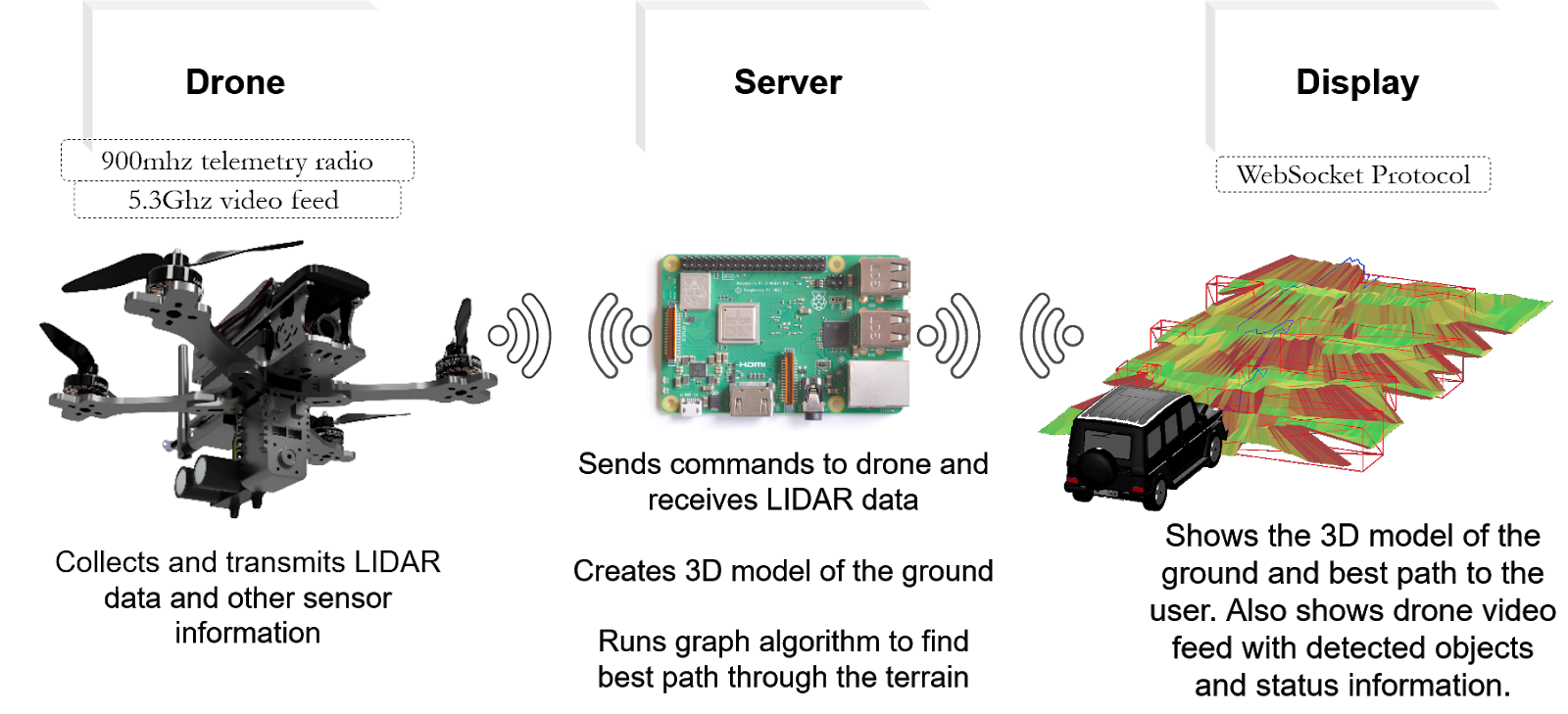
Drone
- PX4 drone firmware
- LIDAR sensor for scanning
Server
- Raspberry Pi Server, running A* best path algorithm
- QGroundControl open source ground control
Display
- React Native app
- WebGL rendering used for creating the depth map
Overview
Mercedes is committed to improving the experience customers have with their vehicles. In order to bring more convenience and utility to the user they sponsored our team to build a drone integrated with their SUVs, to provide real-time information on the terrain that a driver cannot directly see and improve off-road safety. We utilized a drone with multiple sensors to achieve:
- A 3D mapping of the environment.
- An algorithm to find the best path through the terrain ahead.
- An intuitive app display showing obstacles and the best path to the user.
Architecture
Challenges
Finding and learning about the combination of technologies such as drone firmware and best path algorithms required to put together this project was our team’s greatest challenge. Ultimately we gathered a strong blend of techniques to give us a stable and reliable system.
Results
- Built a drone capable of taking off and landing from a trunk, scanning the ground in front of the vehicle and returning the LIDAR data back to the server.
- Built a server for communicating between the display and drone.
- Designed an app that is able to show a 3d model of the ground and live video from the drone with obstacle overlay, and help the user navigate the terrain.
Conclusion
Our drone system creates a 3d map of the environment in front of the vehicle and finds the best path through the terrain.
Acknowledgements
We would like to thank our sponsor Mercedes, Jeff Bertalotto, Kevin Gee, Utkarsh Gautam, our TAs Faeze Brahman and Chandranil Chakrabortti, and Professor Jullig for their support and mentorship.